


Randonnée Cevennes J1

raphael94
User

Length
17 km

Max alt
748 m

Uphill gradient
482 m
Km-Effort
23 km

Min alt
546 m

Downhill gradient
332 m
Boucle
No
Creation date :
2018-06-26 16:19:15.859
Updated on :
2018-06-26 16:19:15.859
4h57
Difficulty : Unknown

FREE GPS app for hiking
 SityTrail
IGN / Geographical institutes
SityTrail Plus
The world is yours!
About
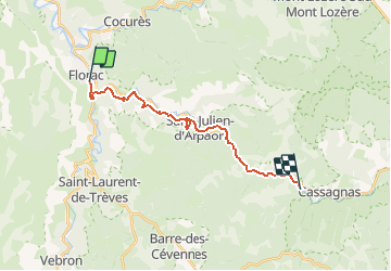
Trail Walking of 17 km to be discovered at Occitania, Lozère, Florac Trois Rivières. This trail is proposed by raphael94.
Positioning
Country:
France
Region :
Occitania
Department/Province :
Lozère
Municipality :
Florac Trois Rivières
Location:
Florac
Start:(Dec)
Start:(UTM)
547601 ; 4907665 (31T) N.
Comments